NWM Coastal: Automated Coastal Model Calibration#
Why This Tool?#
Running coastal models for calibration and forecasting involves many moving parts: downloading and preparing meteorological, ocean boundary, river discharge data, and configuring the model, running on HPC, and validating against observations. Previously, this required 20+ bash scripts with dozens of environment variables, fragile date arithmetic, and manual data management.
coastal-calibration replaces that workflow with a single Python package. One
configuration file drives the entire pipeline, from data download through model
execution to validation against NOAA tide gauges.
What It Does#
- Domain definition: QGIS plugin for interactively drawing the model domain and selecting NWM river discharge points
- Model creation (SFINCS): automated quadtree mesh generation from an AOI polygon
- Data management: download of NWM forcing (retrospective 1979-2023 or real-time analysis), STOFS ocean boundary conditions, and TPXO tidal data with date-range validation
- Forcing preparation: atmospheric regridding via ESMF, boundary condition processing with STOFS/TPXO fallback
- Model execution: SFINCS (single-node OpenMP) and SCHISM (multi-node MPI) with resumable stage-based pipelines
- Validation: automatic NOAA CO-OPS station discovery, water level comparison plots, and flood depth mapping
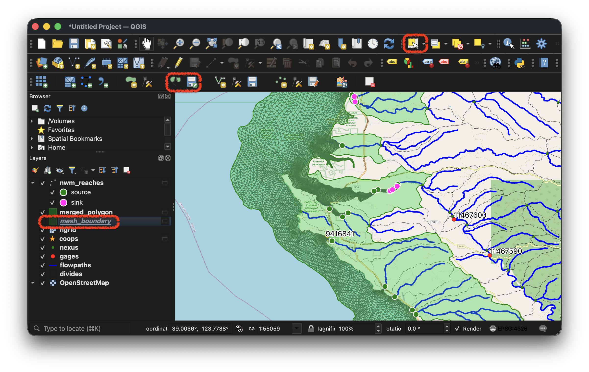
QGIS plugin: defining the model domain aligned to watershed boundaries
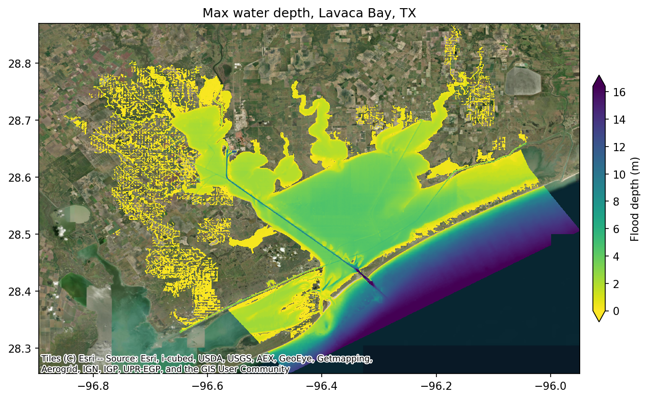
Flood depth map from a SFINCS simulation of Lavaca Bay, TX
Supported Models#
| SFINCS | SCHISM | |
|---|---|---|
| Grid | Quadtree (regular) | Unstructured triangular |
| Compute | Single-node, OpenMP | Multi-node, MPI |
| Model Creation | Automated | Prebuilt mesh required |
| Flood Depth Map | Yes (downscaled to DEM) | Not yet supported |
| Domains | CONUS, Hawaii, Puerto Rico | CONUS, Hawaii, Puerto Rico |
Design#
- Single configuration: one YAML file (or Python dictionary) defines the entire simulation, with validation, sensible defaults, and support for multi-run templates
- Resumable pipeline: each stage (download, forcing, run, plot, ...) can be restarted individually, so a failed run does not need to start from scratch
- Portable: both SFINCS and SCHISM are included as submodules and compiled from source during environment setup, with no containers required. The same workflow runs on a local workstation or an HPC cluster.
- Unified API: the same two Python calls (
CoastalCalibConfig+CoastalCalibRunner) work for both models; only the model-specific settings differ - Built for large models: although written in Python, the package orchestrates compiled libraries for the heavy lifting: ESMF for atmospheric regridding, GDAL/NetCDF/HDF5 for spatial I/O on large files, and lazy loading to avoid reading entire datasets into memory. Python handles the workflow logic while performance-critical operations run in compiled code.
Use Cases#
This package supports two primary use cases:
- Retrospective calibration: run historical simulations against NWM retrospective data (1979-2023) to tune model parameters and validate performance at NOAA gage stations
- Operational forecasting: integrate with the Next Generation Water Modeling
Framework (NGEN) as a coastal model realization, where
coastal-calibrationhandles the model setup, forcing, and execution while NGEN orchestrates catchment-level workflows
Quick Start#
Installation#
Prerequisites: Git and Pixi. Pixi handles all other dependencies including Python and compiling SFINCS and SCHISM from source.
All commands below should be run with pixi r -e dev to activate the environment.
CLI#
Generate a configuration file, adjust it, then run:
# SCHISM (default)
pixi r -e dev coastal-calibration init config.yaml --domain hawaii

# SFINCS
pixi r -e dev coastal-calibration init config.yaml --domain atlgulf --model sfincs
Validate and run:
pixi r -e dev coastal-calibration validate config.yaml
pixi r -e dev coastal-calibration run config.yaml
The pipeline supports --start-from and --stop-after for partial workflows:
pixi r -e dev coastal-calibration run config.yaml --start-from schism_boundary
pixi r -e dev coastal-calibration run config.yaml --stop-after schism_sflux
Python API#
from coastal_calibration import CoastalCalibConfig, CoastalCalibRunner

config = CoastalCalibConfig.from_yaml("config.yaml")
runner = CoastalCalibRunner(config)
result = runner.run()

if result.success:
    print(f"Completed in {result.duration_seconds:.1f}s")
Creating a SFINCS Model#
Build a new SFINCS quadtree model from an AOI polygon:
The AOI polygon and discharge points can be created interactively using the QGIS plugin.
Supported Data Sources#
| Source | Date Range | Description |
|---|---|---|
nwm_retro |
1979-02-01 to 2023-01-31 | NWM Retrospective 3.0 |
nwm_ana |
2018-09-17 to present | NWM Analysis |
stofs |
2020-12-30 to present | STOFS water levels |
tpxo |
N/A (local installation) | TPXO tidal model |
Domains: atlgulf, pacific, hawaii, prvi
Workflow Stages#
SCHISM (11 stages)#
download → schism_forcing_prep → schism_forcing → schism_sflux → schism_params
→ schism_obs → schism_boundary → schism_prep → schism_run → schism_postprocess
→ schism_plot
SFINCS (14 stages)#
download → sfincs_symlinks → sfincs_data_catalog → sfincs_init → sfincs_timing
→ sfincs_forcing → sfincs_discharge → sfincs_precip → sfincs_wind →
sfincs_pressure → sfincs_write → sfincs_run → sfincs_floodmap → sfincs_plot
SFINCS Creation (9 stages)#
create_grid → create_fetch_data → create_elevation → create_mask →
create_boundary → create_discharge → create_subgrid → create_obs →
create_write
Roadmap#
- SCHISM model creation: integrate the existing SCHISM mesh subsetting capability into the package, providing an automated create workflow for SCHISM similar to what SFINCS already has. This will allow users to extract a regional subdomain from a larger SCHISM mesh using the same QGIS plugin and API. When this lands, the discharge source/sink generation step needs to use the upstream-crossing strategy described in docs/dev/schism_sink_source_issue.md rather than the per-crossing classification used to build the current pre-built Pacific/Hawaii meshes (which produces multiple spurious source/sink points along each river inside the domain).
- STOFS-aware TPXO fallback: the boundary pipeline currently overwrites STOFS data
with TPXO tidal predictions whenever the simulation exceeds 180 hours, which
silently loses storm surge / wind setup / pressure effects on retrospective runs
where STOFS data is available for the full window. Replace the unconditional
>180h → TPXOswitch inmake_stofs_boundarywith a data-availability check; only fall back when STOFS doesn't cover the requested window (i.e. prospective forecasts beyond the latest available cycle). Smaller, lower-risk fix that should land before the larger multi-cycle/Python-TPXO work below. See docs/dev/stofs_tpxo_improvements.md Phase 1. - Improved tidal boundary conditions: replace the current 8-constituent TPXO implementation with a pure-Python module supporting all 32+ constituents and minor constituent inference, removing the dependency on an external Fortran binary. See docs/dev/stofs_tpxo_improvements.md Phase 4 for the detailed plan and the suspected nodal-correction bugs in the OTPS Fortran code.
- Multi-cycle STOFS stitching: download and stitch multiple STOFS forecast cycles to cover simulations of any duration, eliminating the current 180-hour single-cycle limit. See docs/dev/stofs_tpxo_improvements.md Phase 2.
- Regional STOFS subsetting: spatially subset the global STOFS output to the model domain before download, reducing data transfer from ~12 GB per cycle to a few hundred MB. See docs/dev/stofs_tpxo_improvements.md Phase 3.
- Re-evaluate
hydromt-sfincs/hydromtpatches: 14 upstream bugs are documented in docs/dev/hydromt_sfincs_issues.md and worked around by monkey-patches insrc/coastal_calibration/sfincs/_hydromt_compat.py. The fixes have been shared with the Deltareshydromt-sfincsmaintainers; the dependency is pinned inpyproject.tomlto commit41aac0aso the patches stay aligned with the upstream API they were written against. Once upstream releases land, audit each patch in_hydromt_compat.py, drop the ones that are no longer needed, and bump the pin (or unpin entirely once all 14 are upstream). - PyPI and conda-forge: publish the package on PyPI and conda-forge so users can
install with
pip install coastal-calibrationorconda install coastal-calibrationwithout cloning the repository - Run-mode-aware output defaults: introduce a
simulation.run_modeconfig key ("forecast"for short-duration operational runs,"retrospective"for long hindcasts) that selects sensible default write cadences for both SCHISM (nspool,ihfskip,nhot_write) and SFINCS (dtmapout,dtrstout,dthisout,dtmaxout) when the user does not explicitly override them. Forecast mode would mirror the per-domain Pacific/Hawaii template stacks (hourly snapshots in 18-48h files, frequent restarts); retrospective mode would favor a single output file and infrequent restarts to reduce storage and metadata pressure on long runs. The existingrun_param_overrideskeys would still take precedence so per-run tuning is unaffected.
Credits#
- NextGen Water Modeling Framework Prototype
- schism-dev community
- Deltares community
License#
BSD-2-Clause. See LICENSE for details.